All About Longest Highway in India | Top 10 Indian Longest National Highways List & Important Facts

Longest highway in india

India has a number of national highways. National Highways link far parts of the country. NH’s plays a vital role in advancing the country’s infrastructure and these Indian National Highways are the main road systems as they connect the northern, southern, eastern, and western parts of India with each other. National Highways Authority of India (NHAI) or Central Public Works Department (CPWD) is the one who took care of these road systems right from construction to maintenance.

Plenty of important National Highways works in North-South and East-West directions. The historical & old Sher-Shah Suri Marg is known as No.1 National Highway, between Delhi and Amritsar. In recent times, NH 44 is the longest highway in India, starting from Kanyakumari in Tamil Nadu to Srinagar of Jammu and Kashmir. According to the old records, the name of this national highway is NH 7, whose northern end was Varanasi of Uttar Pradesh. If you want to study in-depth knowledge about the longest national highway in India, go through this article completely by using the quick links given below.

This Blog Includes:

About Longest Highway in India

As of April 2019, India has 142,126 km (88,313 mi) of National Highways which are constructed and managed by the National Highway Authority of India (NHAI), the National Highways and Infrastructure Development Corporation (NHIDCL), and the public works departments (PWD) of state governments. Students & learners who are reading about the longest highway in India should retain that Indian NH’s join every major city of India from north to south to east to west.

Once you learn the basic information about the Indian national highway then it can be very easy to understand the Longest Highway in India. As per the records, NH 44 is the longest National Highway in India. The old name of National Highway 44 (NH 44) was National Highway 7 (NH 7).

The distance of NH 44 is 3,745 km long and it includes the North-South Corridor of NHDP. It begins from Srinagar in the north and ends in Kanyakumari in the south. The NH 44 highway has come into existence by fusing seven major national highways of old numbers that cover NH 1A, NH 1, NH 2, NH 3, NH 75, NH 26, and NH 7. Check out the Top Ten longest national highways in India from the below table.

Also Refer: Largest and Smallest States of India

Top 10 Longest National Highways In India – Full List

S. No National Highway Distance (in km) Route
1 NH 44 (old NH 7) 3,745 Srinagar to Kanyakumari
2 NH 27 3,507 Porbandar in Gujarat to Silchar in Assam
3 NH 48 (old NH 8) 2,807 Delhi to Chennai
4 NH 52 2,317 Sangrur, Punjab to Ankola, Karnataka
5 NH 30 (Old NH 221) 2,040 Sitarganj in Uttarakhand to Ibrahimpatnam in Andhra Pradesh.
6 NH 6 1,873 Jorabat in Meghalaya and terminates at Selling in Mizoram
7 NH 53 1,781 Hajira in Gujarat and Pradip port in Odisha.
8 NH 16 (Old NH 5) 1,711 East coast of West Bengal to Chennai in Tamil Nadu.
9 NH 66 (Old NH 17) 1,622 Panvel and terminates at Kanyakumari
10 NH 19 (Old NH 20) 1,435 Delhi to Kolkata
11 NH 34 1,426 Gangotri Dham in Uttarakhand to Lakhnadon in Madhya Pradesh

Map of NH 44 – Longest National Highway in India

This longest highway covers the range from Srinagar to Kanyakumari(North-South Corridor) with a length of 3700km. Check out the map from the below image and remember the highlighted points about the Indian longest highway.

longest national highway nh44 route map image

List of Cities That Covered By NH 44

The main cities through which the highway NH 44 passes beginning from the north are enlisted here:

  • Srinagar
  • Anantnag
  • Domel
  • Jammu
  • Pathankot
  • Jalandhar
  • Ludhiana
  • Ambala
  • Kurukshetra
  • Panipat
  • Sonipat
  • Delhi
  • Faridabad
  • Mathura
  • Agra
  • Gwalior
  • Jhansi
  • Sagar
  • Lakhnadon
  • Seoni
  • Nagpur
  • Adilabad
  • Nizamabad
  • Kamareddy
  • Hyderabad
  • Kurnool
  • Anantapur
  • Bengaluru
  • Salem
  • Namakkal
  • Karur
  • Dindigul
  • Madurai
  • Tirunelveli
  • Kanyakumari

Important Facts About Longest & Shortest Highways in India

Here are some facts regarding the Indian longest highways. These points are very important & helpful for students to answer General Knowledge Questions in the appearing various competitive exams & govt exams. So, take a look at these facts and get a good grip on the details of the longest highway in India.

  • India has the second-largest road network in the world.
  • Nearly 200 national highways and their cumulative length add up to 101,011 km. The total length of state highways in India adds up to 1,31,899 km.
  • The main highway is of a 2-digit number and all the highways that are enumerated in three digits are technically branches to the main highway.
  • For instance, 144 number highway is a secondary branch of highway number 44. These are further divided into sub-divisions and noted with a suffixed alphabet, like 144A, 244A, etc.
  • The national highways consume only 1.8% of all Indian roads. Yet they control 40% of road traffic in the country.
  • The longest highway in India is NH 44 and it connects the cities from Srinagar to Kanyakumari.
  • Leh-Manali Highway is the world’s second highest-altitude motor highway that connects Shimla in Himachal Pradesh to Leh in Jammu and Kashmir.
  • Facts about National Highways Colors:
    • Yellow and white color is for national highways.
    • Green and white for state highways
    • Black and white is for city highway
  • The smallest national highway is NH 118 along with NH 548. NH 118 connects the cities from Asanbani to Jamshedpur in the state of Jharkhand, running for a distance of only about 5 km. The NH 548 crosses the state of Maharashtra for about 5 km in length.

FAQs on Longest National Highways of India

1. Is NH 44 same as NH 7?

National Highway 44 (NH 44) is the longest highway in India and prior it was known as NH 7 with 3,745 km long and covers the North-South Corridor of NHDP. So, NH 44 and NH 7 are the same.

2. Which cities does the National Highway 44 connect?

NH 44 connects the cities right from Srinagar in the north to Kanyakumari in the south.

3. What is the new name of NH 8?

Even after 7 years also old highway names were changed. So, NHAI mentions the Delhi-Mumbai stretch as NH-8 previously and now its new name is NH 48.

4. Which is the smallest highway in India?

The smallest national highway in India is NH 118 as well as NH 548.

Rivers of the World: List of Top 10 Longest Rivers in the World, Facts about World’s Biggest Rivers

top 10 longest river in the world

Do you know the answer to the question “What is the Longest River in the World?” If yes, then you have an execellent knowledge of World GK topics like the world’s longest river, etc. If not, don’t worry because this article will completely make you understand the topic of the longest river in the world.

Also, we help you to gain some basic knowledge on world GK by providing this direct General Knowledge Article. Make use of that and become pro in answering all General Awareness & current affairs questions asked in the competitive exams.

This page includes all necessary information about Top 10 biggest rivers in the world along with neat explanations and essential details. So, go through the below modules, and let’s grasp all the details of the World’s largest rivers.

Know More:

List of Top 10 Biggest & Longest Rivers in the World

The River Nile is the longest river that is 7088 kilometers in length whereas Amazon is the largest river in the world. Rivers are the most crucial aspect and always been the place where the greatest civilizations bloomed. Rivers offer water for the essential needs of both tiny towns and huge cities.

Also Refer: Longest River in India

The river is a part of the Hydrological cycle. Basically, it is a natural flowing watercourse, often freshwater, streamlined towards an ocean, sea, lake, or another river. Here in the below table, we have shared the Top 10 World’s Longest Rivers list along with length, location, drain name, drainage area, and covered countries.

List of Longest Rivers of the World
River Name Location Length (Miles) Length (Km) Drain Countries
Nile Africa 4130 6650 Mediterranean Sea
  • Ethiopia,
  • Eritrea,
  • Sudan,
  • Uganda,
  • Tanzania,
  • Kenya,
  • Rwanda,
  • Burundi,
  • Egypt,
  • Democratic Republic of the Congo,
  • South Sudan
Amazon South America 4086 6575 Atlantic Ocean
  • Brazil,
  • Peru,
  • Bolivia,
  • Colombia,
  • Ecuador,
  • Venezuela,
  • Guyana
Yangtze China 3917 6300 South China Sea China
Mississippi USA 3902 6275 Gulf Of Maxico USA, Canada
Yenisei-Angara-Selenge-Ider Russia 3445 5539 Kara Sea Russia, Mongolia
Yellow China 3398 5464 Bohai Sea China
Ob-Irtysh Russia 3364 5410 Gulf of Ob
  • Russia,
  •  Kazakhstan,
  • China,
  • Mongolia
Parana Uruguay 3030 4880 Rio de la Plata
  • Brazil,
  • Argentina,
  • Paraguay,
  • Bolivia,
  • Uruguay
Congo Africa 2922 4700 Atlantic Ocean
  • Democratic Republic of the Congo,
  • Central African Republic,
  • Angola,
  • Republic of the Congo,
  • Tanzania,
  • Cameroon,
  • Zambia,
  • Burundi,
  • Rwanda
Amur Asia 2800 4480 Sea of Okhotsk Russia, China, Mongolia

Must Check: Rivers In India: List of Major Rivers of India for UPSC, Bank, SSC Exams 

Detailed Analysis on Top 5 Longest Rivers of the World

A detailed analysis of the first 10 longest rivers in the world is presented below:

1. Nile River: 6650 Km – The longest river in the world

Nile River - longest river in the world

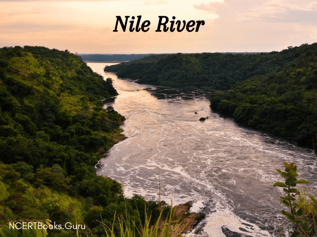
River Nile is the World’s First Longest River located in North-East Africa. It is the lifeline of a number of countries namely, Tanzania, Uganda, Rwanda, Burundi, the Democratic Republic of the Congo, Kenya, Ethiopia, Eritrea, South Sudan, Sudan, and Egypt share its water. The Longest River Nile has two central tributaries- the Blue Nile and the White Nile which is the origin of the river and starts from the Kagera river at the lake headwaters in Burundi, Central Africa. The length of the Nile River is 6650 Kms and flows into the Mediterranean sea. Moreover, it has a discharge of approximately 3.1 million litres per second.

2. Amazon River: 6575 Km – The first largest by waterflow & second-longest by length

Amazon River the largest river of the world

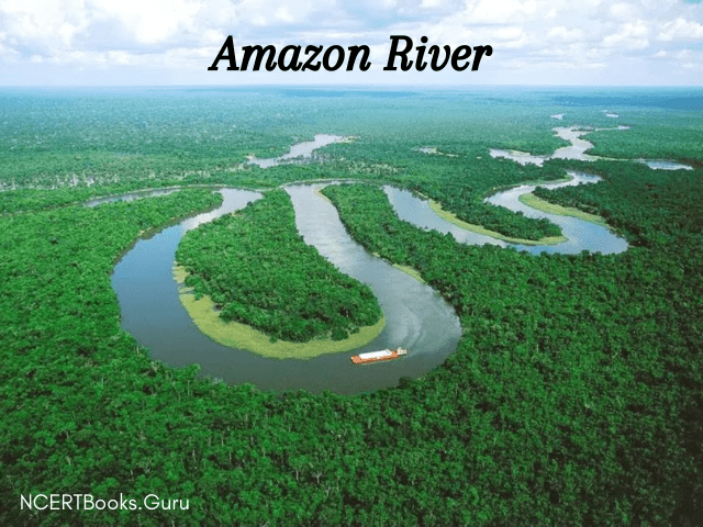
The Second Longest River in the World with a length of 6,400 km is the Amazon River and it has 1100 tributaries and covers 40% of South America – Ecuador, Bolivia, Colombia, Venezuela, Brazil. Also, it is the largest river in the world by waterflow. A recent 2014 study demands that the origin of the Amazon can be drawn to the Cordillera Rumi Cruz. Its origin is the Peruvian rivers in the high Andes mountains.

3. Yangtze River: The longest river in Asia

Yangtze River

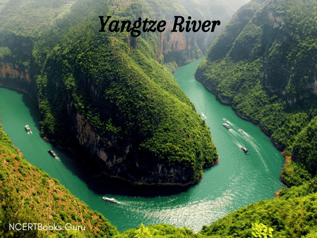
The Third Longest River in the World is the Yangtze River and also it is Asia’s longest river that flows entirely within one country. Since ancient times, the government of China identifies the Tuotuo tributary found in the Tanggula Mountains as the origin of the river. It is 6,300 km long and it has 8 principle tributaries and more than 700 minor tributaries including 20% of China passing 9 provinces of the people’s republic. The Three Gorges Dam on the Yangtze River is the world’s largest Hydro-electric Dam and around 5000 constructed dams are across the river.

4. The Mississippi River

Mississippi Missouri river

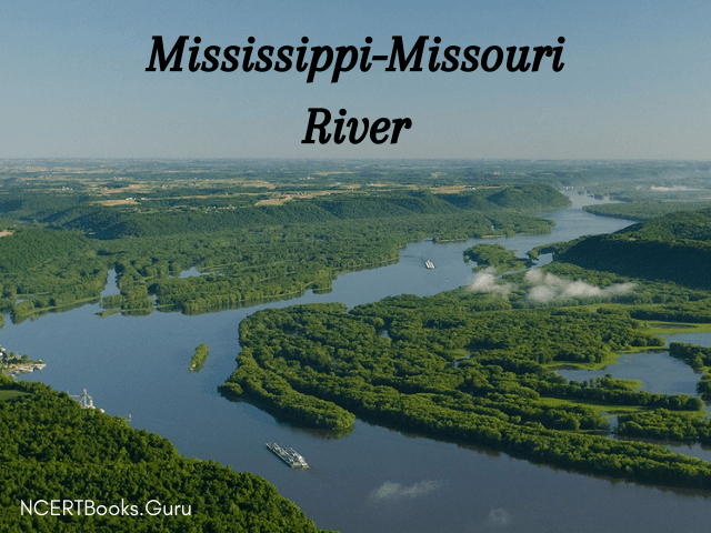
The 4th longest river in the world is the Mississippi River and it is discovered in North America. It is 6,274 km long and flows towards the Gulf of Mexico. The river system flows 31 US states and 2 Canadian territories. The Mississippi River originates in northern Minnesota where Lake Itasca is considered to be the origin of the river and drains into the Gulf of Mexico. For 360 species of fish, 326 species of birds, 145 species of amphibians, and 50 species of mammals, the river Mississippi became a house.

5. The Yenisei River

The Yenisei River

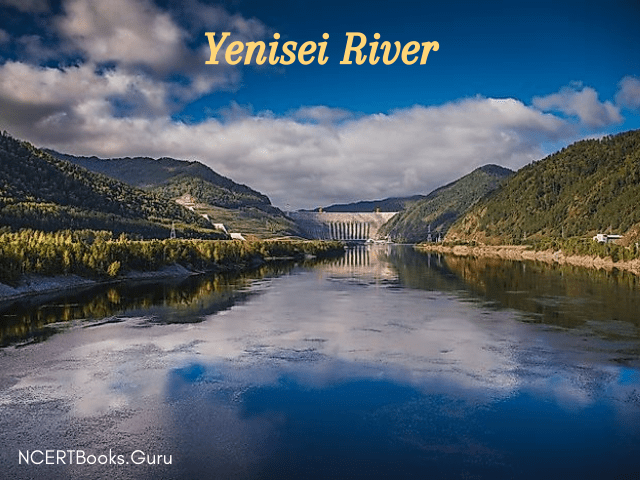
The total length covered by the Yenisei River is 5,539 miles and it mainly flows in Russia and the rest in Mongolia. Yenisei River is the fifth-longest river system in the world and the largest draining into the Arctic Ocean into the Kara Sea. Actually, it begins from the headwaters of the Selenga River about western Mongolia near the Khangai mountains. The Selenge River is 992 km long and flows into Lake Baikal.

Also, Check Related World GK Topics

List of Top 50 World’s Longest & Largest Rivers with Description

The following table enlists the top 50 biggest rivers in the world along with complete descriptions like the length of each river, their source, and the countries touch or crossed or flow through.

Name Of River Description
Nile Source: Kagera – Ruvubu,in Burundi. Mouth: Egypt – Mediterranean Sea.

Length: 6695 Kms.

Countries Crossed: Uganda, Ethiopia, Sudan, Burundi, Egypt.

Amazon Source: Peruvian rivers in the high Andes mountains- Marañón – Apurímac – Mantaro.Mouth: Atlantic ocean.

Length: 6575 Kms.

Countries Crossed: Ecuador, Colombia, Venezuela, Bolivia, Brazil.

Yangtze Source: Wulan Mulun river – Tanggula Mountains – southern Qinghai province -Tibet Autonomous Region.Mouth: East China Sea- near Shanghai.

Length: 6300 Kms.

Countries Crossed: 9 provinces of China.

Mississippi Source: Lake Itasca – Northern Minnesota.Mouth: Gulf Of Mexico.

Length: 3778 Kms.

Countries Crossed: 10 states of the U.S.

Yenisei-Angara-Selenge-Ider Source: The headwaters of the Selenga River – western Mongolia – Khangai mountains.Mouth: Yenisey Gulf – Arctic ocean – Russia.

Length: 3,487 Kms.

Countries Crossed: Russia, Mongolia.

Yellow Source: Bayan Har Mountains – Bayankala mountains – Qinghai province.Mouth: Bohai sea – Dongying – Shandong province.

Length: 5464 Kms.

Countries Crossed: 9 provinces of China.

Ob-Irtysh Source: Asian Altai Mountains- Biya river- Katun river.Mouth: Gulf of Ob- Arctic ocean.

Length: 5410 Kms.

Countries Crossed: Russia, Kazakhstan, China, Mongolia.

Río De La Plata – Paraná-Río Grande Source:Paranaíba -Grande.Mouth: Rio de la Plata – Atlantic Ocean.

Length: 4880 Kms.

Countries Crossed: Brazil, Argentina, Paraguay, Bolivia, Uruguay.

Congo- Chambeshi Source: Lake Mweru – East African Rift – Chambeshi River – Lake Tanganyika.Mouth: Atlantic Ocean.

Length: 4700 Kms.

Countries Crossed: The Democratic Republic of the Congo, Central African Republic, Angola, Republic of the Congo, Tanzania, Cameroon, Zambia, Burundi, Rwanda.

Amur – Argun -Kherlen Source: Reka Argun – Onon river – Shilka river – Kherlen river.Mouth: Sea of Okhotsk.

Length: 4444 Kms.

Countries Crossed: Russia, China, Mongolia.

Lena Source: Baikal Mountains – Central Siberian Plateau.Mouth: Laptev Sea.

Length: 4400 Kms.

Countries Crossed: Russia.

Mekong Source: Lasagongma Spring – plateaus of Tibet.Mouth: South China Sea.

Length: 4350 Kms.

Countries Crossed: China, Myanmar, Laos, Thailand, Cambodia, Vietnam.

Mackenzie–Slave-Peace-FIinlay Source: Thutade Lake – Northern Interior of BC.Mouth: Beaufort Sea.

Length: 4241 Kms.

Countries Crossed: Canada.

Niger Source: Guinea Highlands – southeastern Guinea.Mouth: Gulf of Guinea.

Length: 4200 Kms.

Countries Crossed: Nigeria, Mali, Niger, Algeria, Guinea, Cameroon, Burkina Faso, Côte d’Ivoire, Benin, Chad.

Brahmaputra–Tsangpo Source: Himalayas.Mouth: Ganges.

Length: 3848 Kms.

CountriesCrossed: India, China, Nepal, Bangladesh, Bhutan.

Murray–Darling–Culgoa- Balonne-Condamine Source: Darling Downs – Queensland.Mouth: Southern Ocean.

Length: 3672 Kms.

Countries Crossed: Australia.

Tocantins–Araguaia Source: Brazilian Highlands – Alto Araguaia – Mato Grosso Estado.Mouth: Atlantic Ocean – Amazon

Length: 3650 Kms.

Countries Crossed: Brazil.

Volga Source: Valdai Hills – northwest MoscowMouth: Caspian Sea.

Length: 3645 Kms.

Countries Crossed: Russia.

Indus–Sênggê- Zangbo Source: Gêgyai County -Ngari Prefecture – near Mount Kailash.Mouth: Arabian Sea.

Length: 3610 Kms.

Countries Crossed: Pakistan, India, China.

Shatt-Al–Arab-Euphrates–Murat Source: Tigris- Euphrates confluence – Al- Qurnah – Karun river – Iran – Mount Ararat – Lake Van – Armenian Highlands- Turkey.Mouth: Persian Gulf.

Length: 3596 Kms.

Countries Crossed: Iran, Iraq, Turkey, Syria.

Madeira–Mamoré–Grande–Caine- Rocha Source: Madre de Dois- Mamoré rivers confluence.Mouth: Amazon.

Length: 3380 Kms.

Countries Crossed: Brazil, Bolivia, Peru.

Purús Source: Southern Ucayali headwaters.Mouth: Amazon.

Length: 3211 Kms.

Countries Crossed: Brazil, Peru.

Yukon Source: Llewellyn glacier – southern end – Atlin lake.Mouth: Bering Sea.

Length: 3185 Kms.

Countries Crossed: U.S.A, Canada.

São Francisco Source: Canastra mountains – state – Minas Gerais.Mouth: Atlantic Ocean.

Length: 3180 Kms.

Countries Crossed: Brazil.

Syr Darya – Naryn Source: Tian Shen mountains – Kyrgyzstan – Uzbekistan.Mouth: Aral Sea.

Length: 3078 Kms.

Countries Crossed: Kazakhstan, Kyrgyzstan, Uzbekistan, Tajikistan.

Salween Source: Tanggula mountains – Tibetan plateau – Mekong and Yangtze headwaters.Mouth: Andaman Sea.

Length: 3060 Kms.

COUNTRIES CROSSED: China, Myanmar, Thailand.

Saint Lawrence–Niagara–Detro–Saint- Clair- Saint Marys–Saint Louis–North Source: Lake Ontario – Lake Erie – Lake Saint Clair – Okefenokee swamp – Hoyt Lakes – Saint Louis river.Mouth: Gulf of Saint Lawrence.

Length: 3058 Kms.

Countries Crossed: Canada, U.S.A.

Rio Grande Source: Main Canby mountain.Mouth: Gulf of Mexico.

Length: 3057 Kms.

Countries Crossed: U.S.A, Mexico

Lower Tunguska Source: Central Siberian Plateau.Mouth: Yenisei.

Length: 2989 Kms.

Countries Crossed: Russia.

Danube-Breg (Donau, Dunăre, Duna, Dunav, Dunaj) Source: Furtwangen –  river Brigach – river Breg.Mouth: Black Sea.

Length: 2888 Kms.

Countries Crossed: Romania, Hungary, Austria, Serbia, Germany, Slovakia, Bulgaria, Croatia, Ukraine.

Irrawaddy River–N’MaiRiver–Dulong

River–Kelaoluo–Gada Qu

Source: MaliKha river – Chayu river Tibet – Zhuxian river.Mouth: Andaman Sea.

Length: 2727 Kms.

Countries Crossed: China, Myanmar.

Zambezi Source: Mwinilunga District Zambia.Mouth: Mozambique Channel.

Length: 2693 Kms.

Countries Crossed: Zambia, Angola, Zimbabwe, Mozambique, Malawi, Tanzania, Namibia, Botswana.

Vilyuy Source: Central Siberian Plateau.Mouth: Lena.

Length: 2650 Kms.

Countries Crossed: Russia.

Araguaia Source: Nascente do Rio Araguaia.Mouth: Tocantins.

Length: 2627 Kms.

Countries Crossed: Brazil.

Ganges–Hooghly–Padma(Ganga) Source: Gangotri glacier – Ganges – Himalayas.Mouth: Bay of Bengal.

Length: 2620 Kms.

Countries Crossed: India, Bangladesh, Nepal.

Amu Darya- Panj Source: Pamir mountains Kush.Mouth: Aral Sea.

Length: 2620 Kms.

Countries Crossed: Uzbekistan, Turkmenistan, Tajikistan, Afghanistan.

Japurá-(Rio- Yapurá) Source: Páramo de Las Papas.Mouth: Amazon.

Length: 2615 Kms.

Countries Crossed: Brazil, Colombia.

Nelson–Saskatchewan Source: Lake Winnipeg – The Rocky Mountain.Mouth: Hudson Bay.

Length: 2570 Kms.

Countries Crossed: Canada, U.S.A.

Paraguay(Río-Paraguay) Source: The State Of Mato Grosso.Mouth: Paraná.

Length: 2549 Kms.

Countries Crossed: Brazil, Paraguay, Bolivia, Argentina.

Kolyma Source: Magadan – Okhotsk town.Mouth: East Siberian Sea.

Length: 2513 Kms.

Countries Crossed: Russia.

Pilcomayo Source: Andes mountain range.Mouth: Paraguay.

Length: 2500 Kms.

Countries Crossed: Paraguay, Argentina, Bolivia.

Upper Ob-Katun Source: Near Biysk.Mouth: Gulf Of Ob.

Length: 2490 Kms.

Countries Crossed: Russia.

Ishim Source: Kazakhstan.Mouth: Irtysh.

Length: 2490 Kms.

Countries Crossed: Kazakhstan, Russia.

Juruá Source: Ucayali river Peru.Mouth: Amazon.

Length: 2410 Kms.

Countries Crossed: Peru, Brazil.

Ural Source: Southern Ural Mountains, Russia.Mouth: Caspian Sea.

Length: 2428 Kms.

Countries Crossed: Russia, Kazakhstan.

Arkansas Source: The Rocky Mountains.Mouth: Mississippi.

Length: 2348 Kms.

Countries Crossed: U.S.A.

Colorado (Western U.S.) Source: La Poudre Pass lake headwaters.Mouth: Gulf of California.

Length: 2333 Kms.

Countries Crossed: U.S.A, Mexico.

Olenyok Source: Krasnoyarsk Krai – Vilyuy Plateau – Anabar plateau.Mouth: Laptev Sea.

Length: 2292 Kms.

Countries Crossed: Russia.

Dnieper Source: Valdai Hills – Russia.Mouth: Black Sea.

Length: 2287 Kms.

Countries Crossed: Russia, Belarus, Ukraine.

Aldan Source: Stanovoy Range Russia.Mouth: Lena.

Length: 2273 Kms.

Countries Crossed: Russia.

Facts About Important Rivers of the World

  • The river Nile starts south of the Equator, crosses the Tropic of Cancer, and then drains into the sea.
  • Throughout the entire length of the Amazon river, there are no bridges across it.
  • The Congo River (former name – Zaire river) crosses the Equator twice.
  • The river Limpopo passes the Tropic of Capricorn twice.
  • Saudi Arabia, Kuwait, Yemen, Bahrain, Qatar are the countries that do not have any rivers flowing through them.
  • The River Hwang He or the Yellow River is known as China’s sorrow.
  • River Danube passes through 4 capital cities, Belgrade (Serbia), Budapest (Hungary), Bratislava (Slovakia), and Vienna (Austria).
  • Moreover, the Danube River flows through ten countries viz Austria, Bulgaria, Croatia, Germany, Hungary, Moldova, Romania, Serbia, Slovakia, and Ukraine.

FAQs on Major Rivers in the World

1. Name the 5 longest rivers in the world in order?

The top 5 longest rivers in the world list are provided below:

1. Nile: Africa. 4,180,
2. Amazon: South America. 3,912,
3. Mississippi-Missouri-Red Rock: United States. 3,710,
4. Chang Jiang (Yangtze River): China. 3,602, and
5. Yenisei – Angara – Selenga River: Russia. 3,459.

2. Which is the deepest river on earth?

The deepest river on earth is Congo.

3. Which river is longer Nile or Amazon?

The Amazon is considered the world’s largest river by volume, yet scientists have thought it is somewhat shorter than Africa’s Nile in terms of length.

4. Which is the largest river in the world? 

Amazon is the largest river in the world in terms of discharge volume of water.

Difference between Nagara Style and Dravidian Style & Their Comparisons

Difference between Nagara Style and Dravidian Style

Difference between Nagara and Dravidian Style: India is a country of temples because there are a large number of temples situated all around its different states. People of India worship different gods; thus, this explains the huge number of temples. The temples that are situated in different states are not similar and are distinct from each other.

One of the most important distinguishing features of these temples is architectural design. In North India, the architectural design is known as Nagara Style, whereas in South India, the architectural design is known as Dravidian Style.

You can also find differences between articles on various topics that you need to know. Just tap on the quick link available and get to know the basic differences between them.

What is the Difference between Nagara Style and Dravidian Style?

Both styles are known to be derived from an earlier style which was known as the Panchayatana Style of architecture.

Nagara Style

The architectural design of North Indian temples is known as the Nagara style of agriculture. In this design, Shikara is considered as an essential element or part of the whole temple. Usually, in these temples, the gateway is absent or modest. In these architectural designs, temples have an emphasised boundary. At the entrance of these temples, you can see Dwarpalas.

Dravidian Style

The South Indian architectural styles are considered to be known as the Dravidian Style of architecture. In these temples, the pillar that is used are small but are more in number. These pillars are used over the Garbagriha or sanctuary, which is known as Vimana. The dominating element of these temples is the Gopura of the gatehouse that is present at the edge of the compound. Some ideas in the architectural design are contributed from many kingdoms such as the Cheras, the Pandyas, the Pallavas, the Choras, etc.

Difference between Nagara Style and Dravidian Style

Nagara Style of Architecture Dravidian Style of Architecture
Those temples which are located in North India their architectural design is known as Nagara Style of architecture. Those temples which are located in South India their architectural design is known as Dravidian Style of architecture.
The is more than one Shikhara in these temples. This temple has only one Shikhara.
There are multiple towers in this temple. There is only a single tower in this temple.
The central tower of this temple has a curvilinear shape. The central tower of this temple has the shape of a pyramid.
The most prominent element or part of this temple is the Shikara. The most prominent element or part of this temple is the Gopuram.
In the nagara style of architecture, Ganga and Yamuna rivers are crafted or depicted in a personified form, and this is located at the entrance of the sanctum sanctorum. In the Dravidian Style of architecture, the entrances of the temples are built in such a way that they had Dwarapalas.
The temple’s boundaries are not given that much of importance in this type of architecture. The temple’s boundaries are essential in this type of architecture.
The pedestal in these temples is higher than the ground level. In these temples, the pedestal is present at the ground level
Deities of this temple are placed inside. Deities of this temple are placed outside.

Difference Between Classical Dance and Folk Dance & Their Comparisons

Difference Between Classical Dance and Folk Dance

Difference between Classical and Folk Dance: In India, there are different cultures and religions. Different societies follow these cultures. In an Indian citizen life, culture plays an important role. There are different activities that Indians perform, which are related to their culture. Some of these activities are dance, song, plays, etc. Traditional dancing is very popular in India and had gained a lot of respect for India all around the globe.

You can also find differences between articles on various topics that you need to know. Just tap on the quick link available and get to know the basic differences between them.

What is the Difference Between Classical Dance and Folk Dance?

Traditional dancing gets divided into two types: classical dancing and folk dancing. These two are considered as the major dance forms of India. The key difference between these two is their place of origin. Classical dancing is deeply related to Natya Shastra, whereas folk dancing got introduced from the local tradition of the respective state or geographical regions.

Classical Dancing

A group of dance gets classified under classical dancing which has there origins from Natya Shastra. Natya Shastra is considered as the ancient text for theatre and drama. Classical dance forms are considered to be well-developed on the basis of their technique, grammar and execution. These dance forms are taught through a guru-shishya relationship that has been there for years. This dance form is considered to be stylized and performance-oriented.

Folk Dancing

Folk dancing is a type of dance form that gets developed with the help of people who are reflecting their own lives, often to the local music. Folk dance is a type of group dance, and the objective of these dance performances are aimed for celebratory purposes such as harvest, weddings, etc. To perform this dance one need not have to go through training, but he/she have to mirror the steps that are being taught. The whole objective of performing these dance is enjoyment and nothing else.

Difference Between Classical Dance and Folk Dance

Classical Dance Form Folk Dance Form
The classical dance form has its origin from Natya Shastra. The two basic aspects of classical dance are considered to be Lasya and Tandava. Folk dance is a kind of dance form that gets originated when people start reflecting their lives often to a piece of local music.
It is believed that the classical dance form is related to spirituality. This dance form is associated with celebrating agricultural harvest or social gatherings such as weddings, birthday, etc.
Classical Dance is considered to be more demanding, and it is always strict with the technical aspects that are present. Folk dancing is considered to be free and funny. This dance form is based on various local stories that are about relationships between two people or two seasons.
Grace and composure are what you can expect from a classical dance form. Enthusiasm and power are what you can expect from folk dancing.
Classical dance is performed by experts who have years of experience or have been trained for years on how to perform this dance form. Folk dance is not performed by experts or professionals because this type of dance forms are generally performed by common people.
In India, there are a total of 8 classical dances. In India, there are more than 30 forms of folk dance in different states.

Difference Between Relative Poverty and Absolute Poverty & Their Comparisons

Difference Between Relative Poverty and Absolute Poverty

Difference Between Relative Poverty and Absolute Poverty: Poverty is considered as a state or condition of a country, where people do not have the minimum financial resources that are required for maintaining a minimum standard of living. In other words, poverty is such a situation in which the income level from employment is so low that it can’t afford the normal needs of a person’s life.

You can also find differences between articles on various topics that you need to know. Just tap on the quick link available and get to know the basic differences between them.

What is the Difference Between Relative Poverty and Absolute Poverty?

People who get hit by poverty face a lot of problems such as no housing, unclean water, starving to eat and no medical attention. Every country has a certain number of people who are under the poverty level.

Poverty is classified into two types which are relative poverty and absolute poverty. Let’s discuss more on this classification:

Relative Poverty

Relative poverty is a situation where the persons who got hit by these earn 50% less than the average income of the households of that area. Thus, it implies that the households have some money, but that is not enough to afford anything that is above the basics. This type of poverty is flexible and changes with the change in the economic growth of a country. Thus, it means that relative poverty depends on the economic growth of the country. Relative poverty is also known as relative deprivation.

Absolute Poverty

Absolute poverty is a situation where the persons who got hit by these earns money under a certain level which is not enough even to buy the basic needs of a person. A person’s basic needs are food, shelter, cloth, safe drinking water, healthcare, and education. A person cant utilize these basic needs if he/she get hit by absolute poverty. This type of poverty doesn’t depend on the economic growth of the country. Even if the economy is growing, people who are under absolute poverty remains there.

Difference Between Relative Poverty and Absolute Poverty

Relative Poverty Absolute Poverty
Relative poverty does not focus or concentrate on the biological needs of a person but is involved in comparing the incomes of two people living in the same environment. A person who is not even capable of buying essential needs for him/her comes under this poverty—essential needs such as food, shelter, cloth education, etc.
While measuring relative poverty, income level is not considered, which is why a person who is meeting his/her personal needs is also considered poor under this case. While measuring absolute poverty, the income level of persons is considered.
Although people living in relative poverty earn more than people living in absolute poverty they still earn less than others who are living in the same society Under absolute poverty, the broader quality of life issues is not considered. The overall level of inequality is also not considered here.
This poverty is measured using Gini-Coefficient and Lorenzo Curve. This poverty is measured using the poverty line.
There is Little possibility of eradication if this poverty. There is no possibility of eradication of this poverty.
Quality of life is a little better than those who are living in absolute poverty. Quality of life is poor.

All About Smallest Country in the World | Check the List of Top 10 Smallest Countries of the World by Area

smallest country in the world

Guys who are wondering about which is the smallest country in the world? can refer to this article completely. This guide will make you learn about the world’s smallest country details as well as the list of Top 100 smallest countries in the world. You guys can be shocked after knowing that there are countries that are smaller than the parks in a district or a city.

Both area-wise and population-wise the world’s smallest country is the same and it is an European landlocked Country next to Italy. This country was developed by some popes to indicate their superiority through the region. Know more about the smallest country in the world – The Vatican City from this page.

Also Check: GK General Knowledge 

Smallest Country in the World – Vatican City, Italy

The Vatican City is the world’s smallest country with an area of 0.49 square kilometers and a population of only 825 members. Also, this city is in the capital of another country and it is totally under the Italian capital Rome and is the center of the Catholic Church. It is also termed the Holy See. 75 percent of the Vatican’s citizens are officers of the Clergy. The city is known for its biggest church in the world ie., St. Peter’s Basilica where you guys can find the most important artworks of the old period like The Pieta and the Creation of Adam. Its GDF is all in accordance with the contributions or donations gave by the Roman Church across the world and Christianity worshipers.

List of Top 10 Population-Wise Smallest Countries of the World

There are two categories that you can use to define the smallest country in the world with ease. Those are land area and population. Here in this section, we have furnished the population-wise smallest countries list of the world in the form of a table. Check out the table below and memorize the top 10 smallest countries in the world by population.

Country Population Area (km2)
Vatican City 825  0.44
Tuvalu 11,508 26
Nauru 12,704 21
Palau 17,907 459
San Marino 33,785 61
Liechtenstein 38,557 160
Monaco 38,682 2.02
Saint Kitts and Nevis 52,441 269
Marshall Islands 58,413 181
Dominica 71,625 750

Top 10 Smallest Countries in the World By Area List

Here we have presented the list of the Top 10 world’s smallest countries in terms of an area. If you consider the total area of the country to find out the world’s smallest country then Vatican City is the smallest country with an area of 0.49 square kilometers. Also, check out the remaining nine smallest countries in the world with a total area of land.

Rank Country Area (km2) Area (mi2) Continent Bordering countries by land
1 Vatican City 0.49 0.19 Europe Italy
2 Monaco 2.02 0.78 Europe France
3 Nauru 21 8.1 Australia and Oceania
4 Tuvalu 26 10 Australia and Oceania
5 San Marino 61 24 Europe Italy
6 Liechtenstein 160 62 Europe Austria, Switzerland
7 Marshall Islands 181 70 Australia and Oceania
8 Saint Kitts and Nevis 269 104 North America
9 Maldives 300 116 Asia
10 Malta 316 122 Europe

Related Articles:

List of Top 100 World’s Smallest Countries in terms of Area

Here is the list of 100 top smallest countries in the world by total land area. Take a look at the tabulated list and remember the world GK to score high in the competitive exams.

Rank Country Total Area in km2 (mi2)
1 Vatican City 0.49 km2 (0.19 mi2)
2 Monaco 2.02 km2 (0.78 mi2)
3 Nauru 21 km2 (8.1 mi2)
4 Tuvalu 26 km2 (10 mi2)
5 San Marino 61 km2 (24 mi2)
6 Liechtenstein 160 km2 (62 mi2)
7 Marshall Islands 181 km2 (70 mi2)
8 Saint Kitts and Nevis 261 km2 (101 mi2)
9 Maldives 300 km2 (120 mi2)
10 Malta 316 km2 (122 mi2)
11 Grenada 344 km2 (133 mi2)
12 Saint Vincent and Grenadines 389 km2 (150 mi2)
13 Barbados 430 km2 (170 mi2)
14 Antigua and Barbuda 442 km2 (171 mi2)
15 Seychelles 452 km2 (175 mi2)
16 Palau 459 km2 (177 mi2)
17 Andorra 468 km2 (181 mi2)
18 Saint Lucia 616 km2 (238 mi2)
19 Federated States of Micronesia 702 km2 (271 mi2)
20 Singapore 726 km2 (280 mi2)
21 Tonga 747 km2 (288 mi2)
22 Dominica 751 km2 (290 mi2)
23 Bahrain 778 km2 (300 mi2)
24 Kiribati 811 km2 (313 mi2)
25 São Tomé and Príncipe 964 km2 (372 mi2)
26 Comoros 1,862 km2 (719 mi2)
27 Mauritius 2,040 km2 (790 mi2)
28 Luxembourg 2,586 km2 (998 mi2)
29 Samoa 2,842 km2 (1,097 mi2)
30 Cape Verde 4,033 km2 (1,557 mi2)
31 Trinidad and Tobago 5,130 km2 (1,980 mi2)
32 Brunei 5,765 km2 (2,226 mi2)
33 Cyprus 9,251 km2 (3,572 mi2)
34 Lebanon 10,452 km2 (4,036 mi2)
35 Jamaica 10,991 km2 (4,244 mi2)
36 The Gambia 1,295 km2 (4,361 mi2)
37 Qatar 11,586 km2 (4,473 mi2)
38 Vanuatu 12,189 km2 (4,706 mi2)
39 Montenegro 13,812 km2 (5,333 mi2)
40 The Bahamas 13,943 km2 (5,383 mi2)
41 imor-Leste 14,919 km2 (5,760 mi2)
42 Eswatini 17,364 km2 (6,704 mi2)
43 Kuwait 17,818 km2 (6,880 mi2)
44 Fiji 18,272 km2 (7,055 mi2)
45 Slovenia 20,273 km2 (7,827 mi2)
46 Israel 20,770 km2 (8,020 mi2)
47 El Salvador 21,041 km2 (8,124 mi2)
48 Belize 22,966 km2 (8,867 mi2)
49 Djibouti 23,200 km2 (9,000 mi2)
50 North Macedonia 25,713 km2 (9,928 mi2)
51 Rwanda 26,338 km2 (10,169 mi2)
52 Haiti 27,750 km2 (10,710 mi2)
53 Burundi 27,834 km2 (10,747 mi2)
54 Equatorial Guinea 28,051 km2 (10,831 mi2)
55 Albania 28,748 km2 (11,100 mi2)
56 Solomon Islands 28,896 km2 (11,157 mi2)
57 Armenia 29,743 km2 (11,484 mi2)
58 Lesotho 30,355 km2 (11,720 mi2)
59 Belgium 30,528 km2 (11,787 mi2)
60 Moldova 33,846 km2 (13,068 mi2)
61 Guinea-Bissau 36,125 km2 (13,948 mi2)
62 Bhutan 38,394 km2 (14,824 mi2)
63 Switzerland 41,284 km2 (15,940 mi2)
64 Netherlands 41,850 km2 (16,160 mi2)
65 Denmark 43,094 km2 (16,639 mi2)
66 Estonia 45,227 km2 (17,462 mi2)
67 Dominican Republic 48,671 km2 (18,792 mi2)
68 Slovakia 49,037 km2 (18,933 mi2)
69 Costa Rica 51,100 km2 (19,700 mi2)
70 Bosnia and Herzegovina 51,209 km2 (19,772 mi2)
71 Croatia 56,594 km2 (21,851 mi2)
72 Togo 56,785 km2 (21,925 mi2)
73 Latvia 64,559 km2 (24,926 mi2)
74 Lithuania 65,300 km2 (25,200 mi2)
75 Sri Lanka 65,610 km2 (25,330 mi2)
76 Georgia 69,700 km2 (26,900 mi2)
77 Ireland 70,273 km2 (27,133 mi2)
78 Sierra Leone 71,740 km2 (27,700 mi2)
79 Panama 75,417 km2 (29,119 mi2)
80 Czech Republic 78,865 km2 (30,450 mi2)
81 United Arab Emirates 83,600 km2 (32,300 mi2)
82 Austria 83,871 km2 (32,383 mi2)
83 Azerbaijan 86,600 km2 (33,400 mi2)
84 Serbia 88,361 km(34,116 mi2)
85 Jordan 89,342 km2 (34,495 mi2)
86 Portugal 92,090 km2 (35,560 mi2)
87 Hungary 93,028 km2 (35,918 mi2)
88 South Korea 100,210 km2 (38,690 mi2)
89 Iceland 103,000 km2 (40,000 mi2)
90 Guatemala 108,889 km2 (42,042 mi2)
91 Cuba 109,884 km2 (42,426 mi2)
92 Bulgaria 111,002 km2 (42,858 mi2)
93 Liberia 111,369 km2 (43,000 mi2)
94 Honduras 112,492 km2 (43,433 mi2)
95 Benin 114,763 km2 (44,310 mi2)
96 Eritrea 117,600 km2 (45,400 mi2)
97 Malawi 118,484 km2 (45,747 mi2)
98 North Korea 120,540 km2 (46,540 mi2)
99 Nicaragua 130,373 km2 (50,337 mi2)
100 Greece 131,957 km2 (50,949 mi2)

FAQs on World’s Smallest Country

1. Which country is the smallest in the world?

The first smallest county in the world is Vatican City with a land area of 0.44 square kilometers and 825 population.

2. What are the top 3 world’s smallest countries?

Vatican City in Italy, Monaco, a principality at the Mediterranean coast and an enclave within Southern France, and Nauru, an island country in the southwestern Pacific Ocean are the three world’s smallest countries.

3. Is Nauru the smallest island country in the world.?

Yes, Nauru is the smallest island country in the world.

4. What are the top 5 smallest countries in the world by area?

The list of the Top 5 smallest countries in the world by area is given below:

1. Vatican City

2. Monaco

3. Nauru

4. Tuvalu

5. San Marino