Population Class 9 MCQs Questions with Answers

Choose the correct option:

Question 1.
Migrations change the number, distribution and composition of the population in
(a) the area of departure
(b) the area of arrival
(c) both the area of departure and arrival
(d) none of the above

Answer

Answer: (c) both the area of departure and arrival


Question 2.
A large proportion of children in a population is a result of
(a) high birth rates
(b) high life expectances
(c) high death rates
(d) more married couples

Answer

Answer: (a) high birth rates


Question 3.
The magnitude of population growth refers to
(a) the total population of an area
(b) the number of persons added each year
(c) the rate at which the population increases
(d) the number of females per thousand males

Answer

Answer: (a) the total population of an area


Question 4.
According to the census 2001, a ‘literate’ persons is one who
(a) can read and write his/her name
(b) can read and write any language
(c) is 7 years old and can read and write any language with understanding
(d) knows the 3‘R’s (readings, writing, arithmetic)

Answer

Answer: (c) is 7 years old and can read and write any language with understanding


Question 5.
Which one of the following country has higher population density than India?
(a) Bangladesh
(b) Nepal
(c) Korea
(d) Canada

Answer

Answer: (a) Bangladesh
Explanation:
Only Bangladesh and Japan have higher average population densities than India. The population density of India in the year 2001 was 324 persons per sq. km.


Question 6.
What percentage of India’s population resides in the most populated state of India, Uttar Pradesh?
(a) 38.96 per cent
(b) 14.37 per cent
(c) 16.16 per cent
(d) 20.56 per cent

Answer

Answer: (c) 16.16 per cent
Explanation:
Uttar Pradesh with a population size of 166 million people is the most populous state of India. Uttar Pradesh accounts for about 16 per cent of the Country’s population.


Question 7.
Which state has the lowest population in India?
(a) Uttar Pradesh
(b) Himachal Pradesh
(c) Sikkim
(d) All of these

Answer

Answer: (c) Sikkim
Explanation:
On the other hand, the Himalayan state Sikkim has a population of just about 0.5 million and Lakshadweep has only 60 thousand people.


Question 8.
India accounts for what percentage of the world population?
(a) 16.7 per cent
(b) 20 per cent
(c) 15 per cent
(d) 18.6 per cent

Answer

Answer: (a)16.7 per cent
Explanation:
India’s population as on March 2001 stood at 1,028 million, which account for 16.7 per cent of the world’s population.


Question 9.
Which is the point of reference from which all other elements are observed?
(a) Fauna
(b) Population
(c) Flora
(d) All of these

Answer

Answer: (b) Population
Explanation:
Population is the pivotal element in social studies. It is the point of reference from which all other elements are observed.


Question 10.
Which one of the following state of India has very low population density?
(a) Arunachal Pradesh
(b) Sikkim
(c) Orissa
(d) All of these

Answer

Answer: (a) Arunachal Pradesh
Explanation:
Densities vary from 904 persons per sq km in West Bengal to only 13 persons per sq km in Arunachal Pradesh.


Question 11.
What do you mean by the magnitude of population growth?
(a) The total population of an area
(b) The number of females per thousand males
(c) The number of persons added each year
(d) None of these

Answer

Answer: (c) The number of persons added each year
Explanation:
The absolute numbers added each year or decade is the magnitude of increase. It is obtained by simply subtracting the earlier population.


Question 12.
Which one of the following state has a population density below 100 persons per square kilometre?
(a) Jammu and Kashmir
(b) Uttarakhand
(c) Nagaland
(d) All of these

Answer

Answer: (a) Jammu and Kashmir
Explanation:
Jammu and Kashmir has a population density below 100 persons per square kilometre; there was an increase of two persons for every 100 persons in the base population.


Question 13.
Which one of the following state has very high population density in India?
(a) West Bengal
(b) Madhya Pradesh
(c) Rajasthan
(d) All of these

Answer

Answer: (a) West Bengal
Explanation:
Densities vary from 904 persons per sq. km in West Bengal to only 13 persons per sq km in Arunachal Pradesh.


Question 14.
Who is resource creating factors as well as resources themselves?
(a) Animals
(b) Human beings
(c) Plants
(d) All of these

Answer

Answer: (b) Human beings
Explanation:
The people make and use resources and are themselves resources with varying quality. The people are important to develop the economy and society.


Question 15.
In how many years is the official enumeration of population carried out for census?
(a) 5 years
(b) 16 years
(c) 2 years
(d) 10 years

Answer

Answer: (d) 10 years
Explanation:
In every 10 years is the official enumeration of population carried out for census. The census of India provides us with information regarding the population of our country.


Question 16.
What is the average sex ratio of India as per 2001 census?
(a) 956
(b) 973
(c) 933
(d) 945

Answer

Answer: (c) 933
Explanation:
The average sex ratio of India as per 2001 census is 933. Kerala has a sex ratio of 1058 females per 1000 males; Pondicherry has 1001 females for every 1000 males.


Question 17.
Which one of the following state in India has a population density below 250 persons per square km?
(a) Punjab
(b) Haryana
(c) Chhattisgarh
(d) None of these

Answer

Answer: (c) Chhattisgarh
Explanation:
Chhattisgarh is the state with population densities below 250 persons per square km. rugged terrain and unfavourable climatic conditions.


Question 18.
A large proportion of children in a population is a result of:
(a) High death rate
(b) High married rate
(c) High birth rate
(d) None of these

Answer

Answer: (c) High birth rate
Explanation:
High birth rate is the result of a large proportion of children in a population. The percentage of children and the aged affect the dependency ratio because these groups are not producers.


Question 19.
What is the main cause for the high growth of our population?
(a) Rise in death rate
(b) Decline of death rate
(c) Decline of birth rate
(d) None of these

Answer

Answer: (b) Decline of death rate
Explanation:
Death rate is the number of deaths per thousand persons in a year. The main cause of the rate of growth of the Indian population has been the rapid decline in death rates.

Natural Vegetation and Wildlife Class 9 MCQs Questions with Answers

Choose the correct option:

Question 1.
To which one of the following types of vegetation does rubber belong to?
(a) Tundra
(b) Tidal
(c) Himalayan
(d) Tropical Evergreen

Answer

Answer: (d) Tropical Evergreen


Question 2.
Cinchona trees are found in the areas of rainfall more than
(a) 100 cm
(b) 50 cm
(c) 70 cm
(d) less than 50 cm

Answer

Answer: (a) 100 cm


Question 3.
In which of the following state is the Simlipal bio-reserve located?
(a) Punjab
(b) Delhi
(c) Odisha
(d) West Bengal

Answer

Answer: (c) Odisha


Question 4.
Which one of the following bio-reserves of India is not included in the world network of bio-reserve?
(a) Manas
(b) Nilgiri
(c) Gulf of Mannar
(d) Nanda Devi

Answer

Answer: (a) Manas


Question 5.
The yak, shaggy-horned wild ox and the Tibetan antelope are found in which one of the following regions?
(a) Tibet
(b) Uttarakhand
(c) Himachal Pradesh
(d) Ladakh

Answer

Answer: (d) Ladakh
Explanation:
Ladakh’s freezing high altitudes are a home to yak, the shaggy horned wild ox weighing around one tonne, the Tibetan antelope, the bharal (blue sheep), wild sheep, and the kiang


Question 6.
Which term is used to denote animal species of a particular region or period?
(a) Fauna
(b) Ferns
(c) Flora
(d) None of these

Answer

Answer: (a) Fauna
Explanation:
The term flora is used to denote plants of a particular region or period. Similarly, the species of animals are referred to as fauna.


Question 7.
Which term is used for virgin vegetation, which have come from outside India are termed as exotic plants.
(a) Indigenous plants
(b) Endemic species
(c) Exotic Plants
(d) None of these

Answer

Answer: (c) Exotic Plants
Explanation:
The virgin vegetation, which are purely Indian are known as endemic or indigenous species but those which have come from outside India are termed as exotic plants.


Question 8.
Which term is used for the original plant cover of an area which has grown naturally?
(a) Garden
(b) Agriculture
(c) Virgin Vegetation
(d) Indigenous species

Answer

Answer: (c) Virgin Vegetation
Explanation:
Natural vegetation refers to a plant community which has grown naturally without human aid and has been left undisturbed by humans for a long time. This is termed as a virgin vegetation.


Question 9.
Which is not included in the group of non-flowering plants?
(a) Orchids
(b) Algae
(c) Fungi
(d) None of these

Answer

Answer: (a) Orchids
Explanation:
Orchids are not included in the group of non-flowering plants cultivated crops and fruits, orchards form part of vegetation but not natural vegetation.


Question 10.
How do forests influences the climate of a place?
(a) Modify local climate
(b) Control wind force and temperature
(c) Cause rainfall
(d) All the above

Answer

Answer: (d) All the above
Explanation:
Forests influence the climate of a place. It controls wind force and temperature and causes rainfall. It provides humus to the soil and shelter to the wild life.


Question 11.
Which type of vegetation zone is found in the higher reaches of the Himalayas?
(a) Tropical
(b) Alpine
(c) Temperate
(d) None of these

Answer

Answer: (b) Alpine
Explanation:
Alpine is the types of vegetation zones are found in the higher reaches of the Himalayas with mean annual average temperature below 7°C.


Question 12.
Which type of vegetation grows in the sandy soil of the desert?
(a) Coniferous trees
(b) Grasslands
(c) Cactus and thorny bushes
(d) None of these

Answer

Answer: (c) Cactus and thorny bushes
Explanation:
The sandy soils of the desert support cactus and thorny bushes while wet, marshy, deltaic soils support mangroves and deltaic vegetation.


Question 13.
The character and extent of vegetation are mainly determined by which of the climatic factor?
(a) Temperature
(b) Humidity
(c) Precipitation
(d) All the above

Answer

Answer: (d) All the above
Explanation:
The character and extent of vegetation are mainly determined by temperature, humidity and precipitation. Extent of vegetation is mainly determined by temperature along with humidity in the air, precipitation and soil.


Question 14.
Which type of vegetation usually develops on undulating and rough terrains?
(a) Mangroves
(b) Grasslands and woodlands
(c) Cactus and thorny bushed
(d) None of these

Answer

Answer: (b) Grasslands and woodlands
Explanation:
The undulating and rough terrains are areas where grassland and woodlands develop and give shelter to a variety of wild life.


Question 15.
Which one of the following species is found in Tibet area?
(a) Yak
(b) Shaggy-horned wild ox
(c) Tibetan antelope
(d) All of these

Answer

Answer: (d) All of these
Explanation:
Ladakh’s freezing high altitudes are a home to yak, the shaggy horned wild ox weighing around one tonne, the Tibetan antelope, the bharal (blue sheep), wild sheep, and the kiang


Question 16.
Ebony, mahogany and rosewood trees are grown in which type of the forests?
(a) Coniferous forest
(b) Tropical rainforest
(c) Tropical thorn forest
(d) None of these

Answer

Answer: (b) Tropical rainforest
Explanation:
The commercially important trees of the tropical rain forest are ebony, mahogany, rosewood, rubber and cinchona.


Question 17.
Why is the southern slopes in Himalayan region covered with thick vegetation?
(a) On account of more exposure to sunlight
(b) On account of more precipitation
(c) On account of less exposure to colder winds
(d) All the above

Answer

Answer: (d) All the above
Explanation:
The southern slopes in Himalayan region covered with thick vegetation as compared to northern slopes of the same hills on account of more exposure to sunlight, more precipitation, and less exposure to colder wind.


Question 18.
Which one of the following state of India has the least percentage of its area under forest cover?
(a) Bihar
(b) Punjab
(c) Madras
(d) Sikkim

Answer

Answer: (b) Punjab
Explanation:
Punjab has the least percentage of its area under forest cover. According to India State of Forest Report 2011, the forest cover in India is 21.05 per cent.


Question 19.
Due to which reason the vegetation of most of the areas has been modified or replaced or degraded?
(a) Change of climate
(b) Human occupancy
(c) Soil erosion
(d) None of these

Answer

Answer: (b) Human occupancy
Explanation:
In the hilly region of central India and the marusthali, the vegetation of most of the areas has been modified at some places, or replaced or degraded by human occupancy.


(a) Match the following:

Column A Column B
(i) Rajaji National Park (a) Assam
(ii) Sanjay Gandhi National Park (b) Rajasthan
(iii) Rajgir National Park (c) Maharashtra
(iv) Simlipal National Park (d) Uttarakhand
(v) Ranganthittu Birds Sanctuary (e) Gujarat
(vi) Kaziranga National Park (f) Uttar Pradesh
(vii) Sariska Wild life Sanctuary (g) Bihar
(viii) Gir National Park (h) Rajasthan
(ix) Dudhwa National Park (i) Kerala
(x) Keoladeo Ghana National Park (j) Odisha
Answer

Answer:

Column A Column B
(i) Rajaji National Park (d) Uttarakhand
(ii) Sanjay Gandhi National Park (c) Maharashtra
(iii) Rajgir National Park (g) Bihar
(iv) Simlipal National Park (j) Odisha
(v) Ranganthittu Birds Sanctuary (i) Kerala
(vi) Kaziranga National Park (a) Assam
(vii) Sariska Wild life Sanctuary (b) Rajasthan
(viii) Gir National Park (e) Gujarat
(ix) Dudhwa National Park (f) Uttar Pradesh
(x) Keoladeo Ghana National Park (h) Rajasthan

(b) Match the following:

Column A Column B
(i) Sundarbans (a) Uttarakhand
(ii) Gulf of Mannar (b) Assam
(iii) The Nilgiris (c) Madhya Pradesh
(iv) Nanda Devi (d) West Bengal
(v) Nokrek (e) Andaman and Nicobar Islands
(vi) Great Nicobar (f) Odisha
(vii) Manas (g) South India
(viii) Simlipal (h) Tamil Nadu
(ix) Pachmari (i) Meghalaya
(x) Agasthyamalai (j) Kerala
Answer

Answer:

Column A Column B
(i) Sundarbans (d) West Bengal
(ii) Gulf of Mannar (h) Tamil Nadu
(iii) The Nilgiris (g) South India
(iv) Nanda Devi (a) Uttarakhand
(v) Nokrek (i) Meghalaya
(vi) Great Nicobar (e) Andaman and Nicobar Islands
(vii) Manas (b) Assam
(viii) Simlipal (f) Odisha
(ix) Pachmari (c) Madhya Pradesh
(x) Agasthyamalai (j) Kerala

Climate Class 9 MCQs Questions with Answers

Choose the correct option:

Question 1.
Which one of the following places receives the highest rainfall in the world?
(a) Silchar
(b) Mawsynram
(c) Cherrapunji
(d) Guwahati

Answer

Answer: (b) Mawsynram


Question 2.
The wind blowing in the northern plains in summers in known as:
(a) Kaal Baisakhi
(b) Loo
(c) Trade winds
(d) None of the above

Answer

Answer: (b) Loo


Question 3.
Which one of the following causes rainfall during winters in north-western part of India?
(a) Cyclonic depression
(b) Retreating monsoon
(c) Western disturbances
(d) Southwest monsoon

Answer

Answer: (c) Western disturbances


Question 4.
Monsoon arrives in India approximately in:
(a) Early May
(b) Early July
(c) Early June
(d) Early August

Answer

Answer: (c) Early June


Question 5.
Which one of the following characteristics the cold weather season in India?
(a) Warm days and warm nights
(b) Warm days and cold nights
(c) Cool days and cold nights
(d) Cold days and warm nights.

Answer

Answer: (b) Warm days and cold nights


Question 6.
In which place in India are houses built on stilts?
(a) Bihar
(b) Assam
(c) Goa
(d) None of these

Answer

Answer: (b) Assam
Explanation:
Houses in Assam are built on stilts. These variations have given rise to variety in lives of people – in terms of the food they eat, the clothes they wear and also the kind of houses they live in.


Question 7.
In which places of India there is very little difference between day and night temperatures?
(a) Bihar
(b) Bangalore
(c) Thiruvananthapuram
(d) All of these

Answer

Answer: (c) Thiruvananthapuram
Explanation:
On the other hand, there is hardly any difference in day and night temperatures in Thiruvananthapuram, the Andaman and Nicobar islands or in Kerala.


Question 8.
Most parts of India receive rainfall during which of the following months?
(a) June to September
(b) May to July
(c) September to March
(d) None of these

Answer

Answer: (a) June to September
Explanation:
Most parts of the country receive rainfall from June to September but some parts like the Tamil Nadu coast get a large portion of its rain during October and November.


Question 9.
Kal Baisakhi is associated with:
(a) Punjab
(b) Odisha
(c) Karnataka
(d) West Bengal

Answer

Answer: (d) West Bengal
Explanation:
In West Bengal, these storms are known as the ‘Kaal Baisakhi’.


Question 10.
What do you mean by weather?
(a) State of the atmosphere over an area at any point of time
(b) Envelope of air surrounding earth
(c) Generalised monthly atmospheric conditions.
(d) None of these

Answer

Answer: (a) State of the atmosphere over an area at any point of time
Explanation:
Weather refers to the state of the atmosphere over an area at any point of time. The elements of weather and climate are the temperature, atmospheric pressure, wind, humidity and precipitation.


Question 11.
Which one of the following is an element of weather and climate?
(a) Atmospheric pressure
(b) Temperature
(c) Humidity
(d) All of these

Answer

Answer: (d) All of these
Explanation:
The elements of weather and climate are the temperature, atmospheric pressure, wind, humidity and precipitation.


Question 12.
Around the time of its arrival, the normal rainfall increases suddenly and continues constantly for several days. This is called:
(a) North-easterlies
(b) Jet stream
(c) South-west monsoon
(d) Burst of the monsoon

Answer

Answer: (d) Burst of the monsoon
Explanation:
Around the time of its arrival, the normal rainfall increases suddenly and continues constantly for several days. This is known as the ‘burst’ of the monsoon, and can be distinguished from the pre-monsoon showers.


Question 13.
Which of the following is a component of westerly flow?
(a) North-easterlies
(b) Jet stream
(c) South-west monsoon
(d) Kal Baishakhi

Answer

Answer: (b) Jet stream
Explanation:
The upper air circulation in this region is dominated by a westerly flow. An important component of this flow is the jet stream.


Question 14.
Which prevents the southwest monsoon winds from escaping from India?
(a) The Indian deserts
(b) The Himalayas
(c) Low pressure over Central Asia
(d) None of these

Answer

Answer: (b) The Himalayas
Explanation:
The Himalayas protect the subcontinent from extremely cold winds from central Asia. This enables northern India to have uniformly higher temperatures.


Question 15.
Which winds brings widespread rainfall over the mainland of India?
(a) Sea breeze
(b) North easterly
(c) Southwest monsoon winds
(d) None of these

Answer

Answer: (c) Southwest monsoon winds
Explanation:
The Southwest Monsoon winds blow over the warm oceans, gather moisture and bring widespread rainfall over the mainland of India.


Question 16.
Which one of the following places in India have cooler climate even during summers?
(a) Jaisalmer
(b) Surat
(c) Mussoorie
(d) All of these

Answer

Answer: (c) Mussoorie
Explanation:
The hills are cooler during summers. Mussoorie in in India have cooler climate even during summers.


Question 17.
What does the word monsoon literally means?
(a) Wind pattern
(b) Change
(c) Seasons
(d) All of these

Answer

Answer: (c) Seasons
Explanation:
The word monsoon is derived from a word which literally means Season. These monsoon winds bind the whole country.


Question 18.
Which is the coldest place in India?
(a) Shillong
(b) Srinagar
(c) Drass
(d) None of these

Answer

Answer: (c) Drass
Explanation:
On a winter night, temperature at Drass in Jammu and Kashmir may be as low as minus 45°C.


Question 19.
Which one of the following states in India suffers from loo?
(a) Maharashtra
(b) Bihar
(c) Gujarat
(d) All of these

Answer

Answer: (c) Gujarat
Explanation:
A striking feature of the hot weather season is the ‘loo’. These are strong, gusty, hot, dry winds blowing during the day mainly in Gujarat.


Question 20.
What causes rainfall in West Bengal during the hot weather season?
(a) Kal Baishakhi
(b) Southwest monsoon
(c) Retreating Monsoon
(d) None of these

Answer

Answer: (a) Kal Baishakhi
Explanation:
The season for localised thunderstorms, associated with violent winds, torrential downpours, often accompanied by hail. In West Bengal, these storms are known as the ‘Kaal Baisakhi’.


Question 21.
Which area is not an area of low precipitation in India?
(a) Assam
(b) Deccan plateau
(c) Both a and b
(d) None of these

Answer

Answer: (a) Assam
Explanation:
Assam is the area of low precipitation. The rest of the country receives moderate rainfall. Snowfall is restricted to the Himalayan region.


Drainage Class 9 MCQs Questions with Answers

Choose the correct option:

Question 1.
The city located on the water divide between the Indus and the Ganga river system is
(a) Jabalpur
(b) Ambala
(c) Meerut
(d) Chandigarh

Answer

Answer: (b) Ambala


Question 2.
Which river is called the Dihang when it enters India in Arunachal Pradesh
(a) The Ganga
(b) The Brahmaputra
(c) The Indus
(d) The Kaveri

Answer

Answer: (b) The Brahmaputra


Question 3.
The world’s largest drainage basin is of the
(a) Amazon river
(b) Nile river
(c) Ganga river
(d) Hwang Ho river

Answer

Answer: (a) Amazon river


Question 4.
Which one of the following peninsular river of India flows west and makes estuaries?
(a) The Krishna
(b) The Mahanadi
(c) The Godavari
(d) The tapi

Answer

Answer: (d) The tapi


Question 5.
The Vembanad Lake is located in
(a) Kerala
(b) Andhra Pradesh
(c) Tamil Nadu
(d) Odisha

Answer

Answer: (a) Kerala


Question 6.
Which one of the following lake is artificial?
(a) Sambhar
(b) Chilika
(c) Pulicat
(d) Rana Pratap sagar

Answer

Answer: (d) Rana Pratap sagar


Question 7.
Which of the peninsular rivers is called the ‘Dakshin Ganga’?
(a) The Mahanadi
(b) The Krishna
(c) Godavari
(d) tha tapi

Answer

Answer: (c) Godavari


Question 8.
The valley of Kashmir is famous for the
(a) Dal Lake
(b) houseboats
(c) shikaras
(d) all of the above

Answer

Answer: (d) all of the above


Question 9.
The Ganga Action Plan (GAP) Phase-I was started in the year:
(a) 1970
(b) 1975
(c) 1980
(d) 1985

Answer

Answer: (d) 1985


Question 10.
The drainage basin of the Mahanadi is not shared by
(a) Madhya Pradesh
(b) Maharashtra
(c) Chhattisgarh
(d) Jharkhand

Answer

Answer: (a) Madhya Pradesh


Question 11.
Which one of the following describes the drainage patterns resembling the branches of a tree?
(a) Radial
(b) Dendrite
(c) Centrifugal
(d) Trellis

Answer

Answer: (b) Dendrite


Question 12.
In which of the following states is the Wular lake located?
(a) Rajasthan
(b) Uttar Pradesh
(c) Punjab
(d) Jammu and Kashmir

Answer

Answer: (c) Punjab


Question 13.
The river Narmada has its source at
(a) Satpura
(b) Dal
(c) Amarkantak
(d) Gobind Sagar

Answer

Answer: (d) Gobind Sagar


Question 14.
Which one of the following lakes is a salt water lake?
(a) Sambhar
(b) Dal
(c) Wular
(d) Gobind Sagar

Answer

Answer: (a) Sambhar


Question 15.
Which one of the following is the longest river of the Peninsular India?
(a) Narmada
(b) Krishna
(c) Godavari
(d) Mahanadi

Answer

Answer: (c) Godavari


Question 16.
Which one amongst the following rivers flows through a rift valley?
(a) Mahanadi
(b) Tungabhadra
(c) Krishna
(d) Tapi

Answer

Answer: (d) Tapi


Question 17.
TheWainganga and the Penganga are tributaries of which of the following rivers?
(a) The Mahanadi
(b) The Narmada
(c) The Godavari
(d) The Krishna

Answer

Answer: (c) The Godavari


Question 18.
Which of the following rivers is not a tributary of river Godavari?
(a) Purna
(b) Ghatprabha
(c) ardha
(d) Pranhita

Answer

Answer: (b) Ghatprabha


Question 19.
Which of the following rivers rises from the slopes of the Western Ghats in the Nasik district of Maharashtra?
(a) Mahanadi
(b) Narmada
(c) Godavari
(d) Koyna

Answer

Answer: (c) Godavari


Question 20.
The drainage basin of which of the following rivers covers parts of Karnataka, Kerala and Tamil Nadu?
(a) Godavari
(b) Krishna
(c) Kaveri
(d) Musi

Answer

Answer: (c) Kaveri


Question 21.
Which of the following rivers originates from the Hazaribagh plateau of Chhota Nagpur region and flows eastwards?
(a) Amravati
(b) Bhima
(c) Ghatprabha
(d) Damodar

Answer

Answer: (d) Damodar


Question 22.
Which type of lakes contain water only during the rainy season?
(a) Oxbow lakes
(b) Lagoons
(c) Lakes in basins of inland drainage
(d) Glacial lakes

Answer

Answer: (c) Lakes in basins of inland drainage


Question 23.
Which one of the following lakes is a saltwater lake?
(a) Wular Lake
(b) Sambhar Lake
(c) Barapani Lake
(d) Dal Lake

Answer

Answer: (b) Sambhar Lake


Question 24.
Which of the following lakes is formed as a result of tectonic activity?
(a) Wular Lake
(b) Kolleru Lake
(c) Loktak Lake
(d) Dal Lake

Answer

Answer: (a) Wular Lake


Question 25.
Which one of the following is not a lake created by human beings?
(a) Gobind Sagar
(b) Nizam Sagar
(c) Barapani
(d) Hirakud

Answer

Answer: (c) Barapani


Question 26.
which of the following states are Nainital and Bhimtal located?
(a) Jammu and Kashmir
(b) Himachal Pradesh
(c) Uttar Pradesh
(d) Uttarakhand

Answer

Answer: (d) Uttarakhand


Question 27.
Lakes are of great value to human beings. Which of the following statements about lakes given below is incorrect?
(a) Helps to regulate the flow of rivers
(b) It results in flooding
(c) Can be used for developing hydel power
(d) Enhances natural beauty

Answer

Answer: (b) It results in flooding


Question 28.
Which of the following is not one of the causes of river pollution?
(a) Dumping of garbage
(b) Aquatic organisms and algae
(c) Discharge of untreated sewage
(d) Discharge of industrial effluents

Answer

Answer: (b) Aquatic organisms and algae


Question 29.
Which of the following is the result of concern over rising pollution in our rivers?
(a) Banning hydroelectric projects
(b) Various river action plans
(c) Rainwater harvesting
(d) None of the above

Answer

Answer: (b) Various river action plans


Describe the following river system under the given column—the Indus, the Ganga and the Brahmaputra.

MCQ Questions for Class 9 Geography Chapter 3 Drainage with Answers 1

Answer

Answer:
MCQ Questions for Class 9 Geography Chapter 3 Drainage with Answers 2


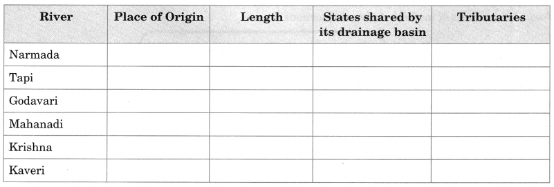
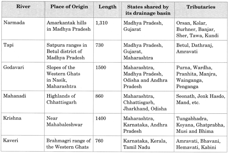
Describe major peninsular rivers under the following column.

MCQ Questions for Class 9 Geography Chapter 3 Drainage with Answers 3

Answer

Answer:
MCQ Questions for Class 9 Geography Chapter 3 Drainage with Answers 4


Physical Features of India Class 9 MCQs Questions with Answers

Choose the correct option:

Question 1.
The northern most range of the Himalayas is known as
(a) Himadri
(b) lesser Himalaya
(c) Shivalik
(d) none of the above.

Answer

Answer: (a) Himadri


Question 2.
The Kangra and Kullu valley are located in
(a) Uttarakhand
(b) Jammu and Kashmir
(c) Himachal Pradesh
(d) Uttar Pradesh

Answer

Answer: (c) Himachal Pradesh


Question 3.
Majuli is a riverine island located in the river
(a) Ganga
(b) Brahmaputra
(c) Yamuna
(d) Kaveri

Answer

Answer: (b) Brahmaputra


Question 4.
Dudhwa National Park is located in the state of
(a) Assam
(b) Uttar Pradesh
(c) Madhya Pradesh
(d) Rajasthan

Answer

Answer: (b) Uttar Pradesh


Question 5.
The soil containing calcareous deposits is locally known as
(a) Bhangar
(b) Khadar
(c) Bhabar
(d) Kankar

Answer

Answer: (d) Kankar


Question 6.
The highest peak in the Eastern Ghats is
(a) Anai Mudi
(b) Doda Betta
(c) Ooty
(d) Mahendragiri

Answer

Answer: (d) Mahendragiri


Question 7.
Jaisalmer is in
(a) Himachal Pradesh
(b) Rajasthan
(c) Gujarat
(d) Uttar Pradesh

Answer

Answer: (b) Rajasthan


Question 8.
Barchans are found in
(a) desert regions
(b) plains
(c) plateaus
(d) hilly regions

Answer

Answer: (a) desert regions


Question 9.
The northern part of the western coast is called the
(a) Konkan
(b) Kannad plain
(c) Malabar coast
(d) Coromandel coast

Answer

Answer: (a) Konkan


Question 10.
Lake Chilika lies in the state of
(a) Jharkhand
(b) Telangana
(c) Odisha
(d) Tamil Nadu

Answer

Answer: (c) Odisha


Question 11.
A landmass bounded by sea on three sides is referred to as
(a) Coast
(b) Island
(c) Peninsula
(d) None of the above

Answer

Answer: (c) Peninsula


Question 12.
Mountain ranges in the eastern part of India forming its boundary with Myanmar are collectively called as
(a) Himachal
(b) Uttarakhand
(c) Purvachal
(d) none of the above

Answer

Answer: (c) Purvachal


Question 13.
The western coastal strip, south of Goa is referred to as;
(a) Coromandel
(b) Konkan
(c) Kannad
(d) Northern Circar

Answer

Answer: (c) Kannad


Question 14.
The highest peak in the Eastern Ghats is
(a) Anai Mudi
(b) Kanchenjunga
(c) Mahendragiri
(d) Khasi

Answer

Answer: (c) Mahendragiri


Question 15.
A narrow gap in a mountain range providing access to the other side is :
(a) Mound
(b) Pass
(c) Strait
(d) Valley

Answer

Answer: (b) Pass


Question 16.
Which two hills are located in the south-east of Eastern Ghats ?
(a) Mizo Hills and Naga Hills
(b) Javadi Hills and Shevroy Hills
(c) Patkoi Hills and Manipuri Hills
(d) Mizo Hills and Patkoi Hills

Answer

Answer: (b) Javadi Hills and Shevroy Hills


Question 17.
The longitudinal valleys lying between lesser Himalayas and Shivaliks are known as .
(a) Kangra Valley
(b) Patkai Bum
(c) Passes
(d) Duns

Answer

Answer: (d) Duns


Question 18.
In which division of the Himalayas are the famous valleys of Kashmir, Kangra and Kullu located?
(a) The Himadri
(b) The Himachal
(c) The Shivaliks
(d) The Duns

Answer

Answer: (b) The Himachal


Question 19.
What are Lesser Himalayas known as?
(a) Himadri
(b) Himachal
(c) Shivaliks
(d) Purvanchal

Answer

Answer: (b) Himachal


Question 20.
Which of the following is the highest peak in India?
(a) Mt. Everest
(b) Kanchenjunga
(c) Nanga Parbat
(d) Nandadevi

Answer

Answer: (b) Kanchenjunga


Question 21.
The Himalayas consist of three parallel ranges in its longitudinal extent. Which of the following is the name of the northern-most range?
(a) The Himadri
(b) The Himachal
(c) The Shivaliks
(d) The Purvanchal

Answer

Answer: (a) The Himadri


Question 22.
Which of the following are young-fold mountains?
(a) The Aravalis
(b) The Nilgiris
(c) The Himalayas
(d) The Sahyadri

Answer

Answer: (c) The Himalayas


Question 23.
Geologically, which of the following physiographic divisions of India is supposed to be one of the most stable land blocks?
(a) The Himalayas
(b) The Northern Plains
(c) The Peninsular Plateau
(d) The Indian Desert

Answer

Answer: (c) The Peninsular Plateau


Question 24.
Which of the following physiographic divisions of India was formed out of accumulations in the Tethys geosyncline?
(a) The Himalayas
(b) The Northern Plains
(c) The Peninsular Plateau
(d) The Indian Desert

Answer

Answer: (a) The Himalayas


Question 25.
Which of the following countries or continents was not a part of the ancient landmass of Gondwanaland?
(a) India
(b) Australia
(c) Europe
(d) South America

Answer

Answer: (c) Europe


Question 26.
Which of the following divisions of India has the oldest landmass?
(a) The Himalayas
(b) The Northern Plains
(c) The Peninsular Plateau
(d) The Indian Desert

Answer

Answer: (c) The Peninsular Plateau


Question 27.
According to the ‘Theory of Plate Tectonics,’ what have been the effects of the movement of the plates?
(a) Change in position and size of continents.
(b) Formation of ocean basins.
(c) Evolution of the present landforms and relief of India.
(d) All of the above.

Answer

Answer: (d) All of the above.


Question 28.
According to the ‘Theory of Plate Tectonics,’ when some plates move away from each other, which of the following is formed?
(a) Convergent boundary
(b) Divergent boundary
(c) Transform boundary
(d) None of the above

Answer

Answer: (b) Divergent boundary


Question 29.
According to the ‘Theory of Plate Tectonics,’ the movement of the plates result in some geological activity. Which one of the following is not such a geological activity?
(a) Volcanic activity
(b) Folding
(c) Faulting
(d) Glaciation

Answer

Answer: (d) Glaciation


Question 30.
Which of the following is a plausible theory presented by Earth scientists to explain the formation of continents and oceans and the various landforms?
(a) Theory of Motion
(b) Theory of Plate Tectonics
(c) Theory of Evolution
(d) Theory of Relativity

Answer

Answer: (b) Theory of Plate Tectonics


Question 31.
Which of the following is responsible for the variation in the colour of soil in different parts of India?
(a) Difference in rock formations
(b) Weathering
(c) Erosion and deposition
(d) Land use

Answer

Answer: (a) Difference in rock formations


Find out some regional names of the Himalayas.

Answer

Answer:
Some regional names of the Himalayas are:

  • Sagarmatha Himal
  • Annapurna Himal
  • Ganesh Himal
  • Langtang Himal
  • Khumbu Himal
  • Dhaulagiri Himal
  • Purvachal
  • Gauri Shankar Himal

Name the famous hill stations of Udagamandalam.

Answer

Answer:

  • Adam’s Fountain
  • Annamalai Ashram Temple
  • Bison Valley
  • Cairn Hill
  • Coonoor
  • Doddabetta Peak

The middle Himalaya is well known for its hill stations. Name some of them.

Answer

Answer:

  • Dalhousie
  • Manali
  • Shimla
  • Nainital
  • Mussoorie
  • Darjeeling


India Size and Location Class 9 MCQs Questions with Answers

Choose the correct option:

Question 1.
The Tropic of Cancer does not pass through
(a) Rajasthan
(b) Orissa (Now Odisha)
(c) Chhattisgarh
(d) Tripura

Answer

Answer: (b) Orissa (Now Odisha)


Question 2.
The eastern most longitude of India is
(a) 97°25’E
(b) 68°7′ E
(c) 77°6’E
(d) 82°32’E

Answer

Answer: (a) 97°25’E


Question 3.
Uttarakhand, Uttar Pradesh, Bihar, West Bengal and Sikkim have common frontiers with
(a) China
(b) Bhutan
(c) Nepal
(d) Myanmar

Answer

Answer: (c) Nepal


Question 4.
If you intend to visit Kavarati during your summer vacations, which one of the following Union Territories of India you will be going to?
(a) Puducherry
(b) Lakshadweep
(c) Andaman & Nicobar
(d) Diu and Daman

Answer

Answer: (b) Lakshadweep


Question 5.
My friend hails from a country which does not share land boundary with India. Identify the country.
(a) Bhutan
(b) Tajikistan
(c) Bangladesh
(d) Nepal

Answer

Answer: (b) Tajikistan


Question 6.
How many states and Union Territories does India have?
(a) India has 26 States and 7 Union Territories
(b) India has 25 States and 7 Union Territories
(c) India has 28 States and 8 Union Territories
(d) India has 28 States and 6 Union Territories

Answer

Answer: (c) India has 28 States and 8 Union Territories


Question 7.
Which line divides India into approximately two equal parts?
(a) Equator
(b) Tropic of Cancer
(c) Tropic of Capricorn
(d) None of these

Answer

Answer: (b) Tropic of Cancer


Question 8.
What is the position of India in the world in respect of area?
(a) 8th position
(b) 7th position
(c) 6th position
(d) 2nd position

Answer

Answer: (b) 7th position


Question 9.
Which meridian is fixed as a Standard Meridian of India?
(a) 82½° E
(b) 84½° E
(c) 86° E
(d) 81° E

Answer

Answer: (a) 82½° E


Question 10.
The latitudinal extent of India lies between
(a) 7° 5′ N and 26° 5′ N
(b) 8° 4′ N and 37° 6′ N
(c) 12° 5′ N and 27° 5′ N
(d) 12° 5′ N and 37° 6′ N

Answer

Answer: (b) 8° 4′ N and 37° 6′ N


Question 11.
Tropic of Cancer passes through which of these states
(a) Orissa
(b) Tripura
(c) Bihar
(d) Punjab

Answer

Answer: (b) Tripura


Question 12.
Which of the following longitudes is selected as the Standard Meridian for India?
(a) 68°7′E
(b) 82°30′E
(c) 97°25′E
(d) 23°30′N

Answer

Answer: (b) 82°30′E


Question 13.
Which of the following is the oldest route of contact between India and other countries of the world?
(a) Ocean routes
(b) Maritime contact
(c) Land routes
(d) Air routes

Answer

Answer: (c) Land routes


Question 14.
How many states and Union Territories are there in India?
(a) 28 states and 7 Union Territories including Delhi
(b) 23 States and 12 Union Territories
(c) 26 states and 9 Union Territories
(d) 30 States and 5 Union Territories

Answer

Answer: (a) 28 states and 7 Union Territories including Delhi


Question 15.
India achieved multi-faceted socio-economic progress during which of the following periods?
(a) Since ancient times
(b) During medieval period
(c) In the 21st century
(d) During the last five decades

Answer

Answer: (d) During the last five decades


Question 16.
Which of the following is the longitudinal extent of India?
(a) 8°4′N and 37°6′N
(b) 68°7′N and 97°25′E
(c) 68°7′E and 97°25′W
(d) 8°4′E and 37°6′E

Answer

Answer: (b) 68°7′N and 97°25′E


Question 17.
The eastern-most longitude of India is
(a) 97°25′E
(b) 68°7′E
(c) 77°6′E
(d) 82°32′E

Answer

Answer: (a) 97°25′E


Question 18.
Which latitude passes through the southern-most point of India’s mainland?
(a) 8°4′N
(b) 37°6′N
(c) 8°4′S
(d) 82°30′E

Answer

Answer: (a) 8°4′N


Question 19.
Which of the following groups of islands belonging to the Indian territory lies in the Arabian Sea?
(a) Andaman and Nicobar Islands
(b) Sri Lanka
(c) Lakshdweep
(d) Maldives

Answer

Answer: (c) Lakshdweep


Question 20.
What is India’s size with respect to other countries of the world?
(a) First
(b) Third
(c) Fourth
(d) Seventh

Answer

Answer: (d) Seventh


Question 21.
Which geographical feature bounds India’s mainland south of 22°N latitude?
(a) Young Fold Mountains
(b) Sandy Desert
(c) Lava Plateaus
(d) Seas and Ocean

Answer

Answer: (d) Seas and Ocean


Question 22.
Both the latitudinal and longitudinal extent of India’s mainland is about 30°. But on looking at the map of India which of the following alternatives do you observe about India’s size?
(a) East-west extent appears to be smaller than north-south extent
(b) East-west extent appears to be larger than north-south extent
(c) East-west and north-south extent appears equal
(d) North-south extent appears to be smaller than east-west extent

Answer

Answer: (a) East-west extent appears to be smaller than north-south extent


Question 23.
If the local time at Dwarka (69°01′E) in Gujarat to the west of India is 6 am, what will be the local time at Dibrugarh (94°58′E approximately 95°), in Assam, in the east?
(a) 4.16 am
(b) 6 am
(c) 7.44 am
(d) 7.44 pm

Answer

Answer: (c) 7.44 am


Question 24.
The Standard Meridian of India, 82°30′E passes through which of the following places?
(a) Kanniyakumari in Tamil Nadu
(b) Walong in Arunachal Pradesh
(c) Kachchh in Gujarat
(d) Mirzapur in Uttar Pradesh

Answer

Answer: (d) Mirzapur in Uttar Pradesh


Question 25.
Which of the following has reduced India’s distance from Europe by 7000 km?
(a) Suez Canal
(b) Panama Canal
(c) Indira Gandhi Canal
(d) Buckingham Canal

Answer

Answer: (a) Suez Canal