NCERT Solutions for Class 9 Social Science Geography Chapter 1 India-Size and Location
Textbook Exercises
Question 1.
Choose the right answer from the four alternatives given below:
(i) The Tropic of Cancer does not pass through:
(a) Rajasthan
(b) Orissa
(c) Chhattisgarh
(d) Tripura
Answer:
(b) Orissa
(ii) The easternmost-longitude of India is:
(a) 97° 25′ E
(b)68°7’E
(c) 37° & E
(d) 82° 32’E.
Answer:
(a) 97° 25′ E
(iii) Uttaranchal, Uttar Pradesh, Bihar, West Bengal and Sikkim have common frontiers with:
(a) China
(b) Bhutan
(c) Nepal
(d) Myanmar
Answer:
(c) Nepal
(iv) If you intend to visit the island Kavaratti during your summer vacations, which one of the following Union Territory of India you will be going to:
(a) Pondicherry
(b) Lakshadweep
(c) Andaman and Nicobar
(d) Diu and Daman.
Answer:
(c) Andaman and Nicobar
(v) My friend hails from a country which does not share land boundary with India. Identify thf country *
(a) Bhutan
(b) Tajikistan
(c) Myanmar
(d) Nepal
Answer:
(c) Myanmar
Question 2.
Answer the following question brifly.
(i) Name the group of islands lying in the Arabian sea?
Answer:
(i) Lakshdweep
(ii) Name the countries which are larger than India?
Answer:
(ii) Russia, China, Canada, USA, Brazil, Australia.
(iii) Which island group of India lies to its south-east
Answer:
(iii) Andaman-Nicobar Islands
(iv) Which island countries are our southern neighbours.
Answer:
(iv) Sri Lanka, Maldives.
Question 3.
The sun rises two hours earlier in Arunachal Pradesh as compared to Gujarat- in the West, but the watches show the same time. How does this happen?
Answer:
The two hours difference between Gujarat and Arunachal Pradesh is because of the two hours time lag. Though the sun rises two hours earlier in Aruncahcal Pradesh than in Gujarat as also in Jaisalmar, yet the standard time remains the same in whole of the country.
Question 4.
The central location of India at the head of the Indian ocean is considered to be a great significance. Why?
Answer:
India’s location at the head of the Indian ocean is itself of great significance. This is evident from the following:
- Because of this location India was able to establish close cultural and commercial contacts with other .countries.
- Due to this location, countries of East Africa, West Asia, East Asia, South and South-West Asia could be reached easily through sea routes.
- India’s eminent position in the Indian Ocean realm justifies naming an ocean after it.
- Because of this location, India is able to maintain direct trade relations not only with the neighbouring countries but also with all the countries of the world.
- Due to this position India gets a very vast and open market very near to it.
Map Skills
Question 1.
Identify the following with the help of map reading:
(i) The Island groups of India lying in the Arabian Sea and the Bay of Bengal.
(ii) The countries constituting Indian Subcontinent.
(iii) The States through which the Tropic of Cancer passes.
(iv) The northernmost latitude in degrees.
(v) The southernmost latitude of the Indian mainland in degrees.
(vi) The eastern and the western most latitude in degrees.
(viii) The place situated on the three seas.
(ix) The strait separating Sri Lanka from India.
(x) The Union Territories of India.
Answer:
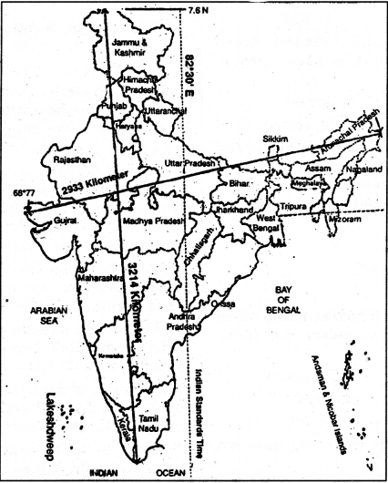
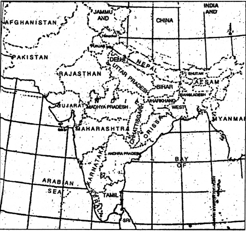
See the following two maps (i) and (ii) of India below :
Map (i)
Map (ii)
Answer:
Hints:
(i) Lakshdweep islands in the Arabian sea and the Andaman and Nicobar Islands in the Bay of Bengal.
(ii) Pakistan, Nepal, Bangladesh, Bhutan, Sri Lanka, Maldives, Myanmar.
(iii) Gujarat, Rajasthan, Madhya Pradesh, Chhatisgarh, Jharkhand, West Bengal, Tripura, Mizoram.
(iv) Indian union (Indira Point) and tne Mariland (Kanyakumari).
(v) 37%’N.
(vi) 8°4′ N.
(vii) 68° 7 E and 97° 25’E,
(viii) Nepal, Bhutan.
(ix) Kanyakumari.
(x) The Palk Strait.
(xi) Delhi, Chandigarh, Pondicherry, Lakeshdweep, Daman and Diu, Dadra and Nagar Haveli, Andaman and Nicobar Islands.
These Solutions are part of NCERT Solutions for Class 9 Social Science. Here we have given NCERT Solutions for Class 9 Social Science Geography Chapter 1 India-Size and Location.